


J4 garins lachat 20k

ophness
User
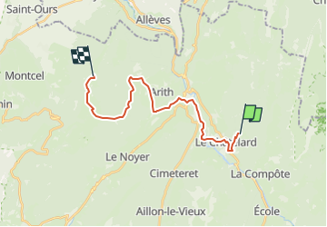

Length
19.2 km

Max alt
1439 m

Uphill gradient
1071 m
Km-Effort
33 km

Min alt
597 m

Downhill gradient
797 m
Boucle
No
Creation date :
2022-05-03 16:50:08.659
Updated on :
2022-05-03 16:58:00.087
4h17
Difficulty : Difficult

FREE GPS app for hiking
 SityTrail
IGN / Geographical institutes
SityTrail Plus
The world is yours!
About
Trail Horseback riding of 19.2 km to be discovered at Auvergne-Rhône-Alpes, Savoy, Le Châtelard. This trail is proposed by ophness.
Positioning
Country:
France
Region :
Auvergne-Rhône-Alpes
Department/Province :
Savoy
Municipality :
Le Châtelard
Location:
Unknown
Start:(Dec)
Start:(UTM)
277808 ; 5063687 (32T) N.
Comments